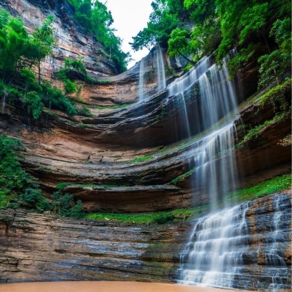
Tat Yai Waterfall is located on Baan Dong Ma Fai Khok Mon Sub-district where is between Nam Nao District, Phetchabun and Phu Pha Man District, Khon Kaen. It is a large waterfall formed by water erosion, creating fractures in the rock layers. The waterfall is divided into two levels: The first section consists of rock layers resembling steps, with a width of 20 meters and a length of approximately 100 meters, extending to the waterfall cliff. The second section is the waterfall cliff, which is about 100 meters high and surrounded by dense forest on both sides, creating a shady and beautiful atmosphere. The rock layers eroded by the waterfall consist of fine sedimentary rocks formed by the accumulation of sediments in a freshwater lake over hundreds of years. Additionally, this waterfall is part of the Korat geological heritage , specifically the Huai Hin Lat Formation , which consists of alternating layers of shale, siltstone, and mudstone. The best time to visit is during the rainy season, from May to August, when the cascading water falls from the cliff, creating a stunning curtain-like waterfall effect.
Visitor Information
- Entry Fee: Free (Thai nationals: Free)
Getting There
Tat Yai Waterfall is located at Nam Nao, Phetchabun. View on Google Maps.
Tips for Visitors
- The trail can be steep — take your time and bring water.
- Litter-free policy — carry out everything you bring in.
- Wear sturdy shoes with grip — rocks are slippery, especially when wet.
- Visit after the rainy season (Oct-Nov) for the best water flow.