Huai Yang Reservoir
อ่างเก็บน้ำห้วยยาง
Huai Yang Reservoir sits inside Ta Phraya National Park in eastern Sa Kaeo, about 90 km (roughly 1.5 hours) from Sa Kaeo town via Highways 33 and 348. Because it’s within the park boundary, the park’s standard entrance fee applies (100 THB for adult foreigners, 20 THB for adult Thai nationals) rather than free entry, despite what older listings for this site claim.
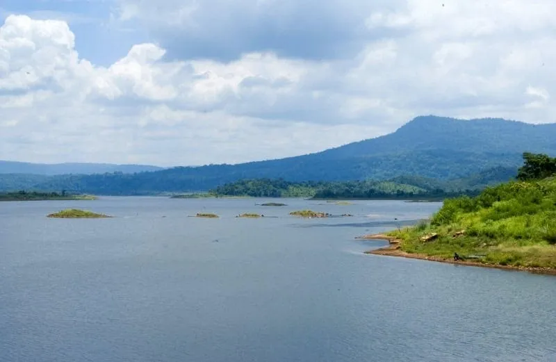
The reservoir itself is a working piece of irrigation infrastructure: a 17-metre earthen dam stretching 3.2 km, built to hold around 60 million cubic metres of water for farmland and flood control in Sa Kaeo’s eastern districts, which sit hard against the Cambodian border. The scale is bigger than it looks from any single viewpoint. The dam crest gives the best sense of it, especially just after the rainy season when the reservoir is near full and the surrounding hills are still green.
Morning is the best time to be here: mist sits on the water, a handful of local fishing boats work the shallows, and waterbirds feed along the margins before the heat sets in. A few basic food stalls near the dam access road sell grilled fish and simple Isan dishes, but don’t expect much beyond that. There’s no restaurant strip or visitor centre at the reservoir itself, and shade is limited once you’re away from the dam.
Insider Tip: Since you’re paying the national park fee anyway, combine the visit with Ta Phraya’s forest trails rather than treating the reservoir as a standalone stop. The park entrance covers both on the same ticket, and the drive out here is long enough that it’s worth making a half-day of it.
Watch out: This stretch of Sa Kaeo borders Cambodia, and some rural roads near the border are less well signed than the main highways. Download an offline map before you set off, and don’t wander off marked tracks near the boundary.
- Entry: 100 THB adult foreigners / 20 THB adult Thai nationals (Ta Phraya National Park fee; children half-price)
- Hours: Daily, 08:00-16:30
- Getting there: ~90 km from Sa Kaeo town via Highways 33 and 348, about 1.5 hours by car
- Dam: 17 m high, 3.2 km long, ~60 million m³ capacity
- Best time: November-February for weather; just after rainy season for a full reservoir
Ta Phraya National Park’s own trails and viewpoints are the natural next stop. See Ta Phraya National Park for the fuller picture of what the same entrance fee covers.
Location & Directions
Ta Phraya, Sa Kaeo
Sa Kaeo, Thailand
Show your taxi or Grab driver
อ่างเก็บน้ำห้วยยาง
Frequently Asked Questions
Is Huai Yang Reservoir free to enter?
How far is it from Sa Kaeo town?
How big is the reservoir?
What's nearby?
When's the best time to visit?
Spotted something out of date or incorrect? Let us know
Stay Near Huai Yang Reservoir
Live prices for places closest to Huai Yang Reservoir: tap a pin to compare.