Ton Sak Yai National Park
อุทยานแห่งชาติต้นสักใหญ่
Ton Sak Yai National Park — still widely known by its original name, Klong Tron — protects about 518.8 square kilometres of forest in Nam Pat district, Uttaradit. It was gazetted as Klong Tron National Park on 4 December 2003 and renamed Ton Sak Yai in a Department of National Parks announcement dated 12 July 2012, after the giant teak tree that grows within its boundary and is reputedly the largest teak in the world (see the dedicated Ton Sak Yai Giant Teak Tree page for that specific stop). The wider park is built around a network of waterfalls, a canal, high cliffs and a marble cave, most of which take real effort to reach.
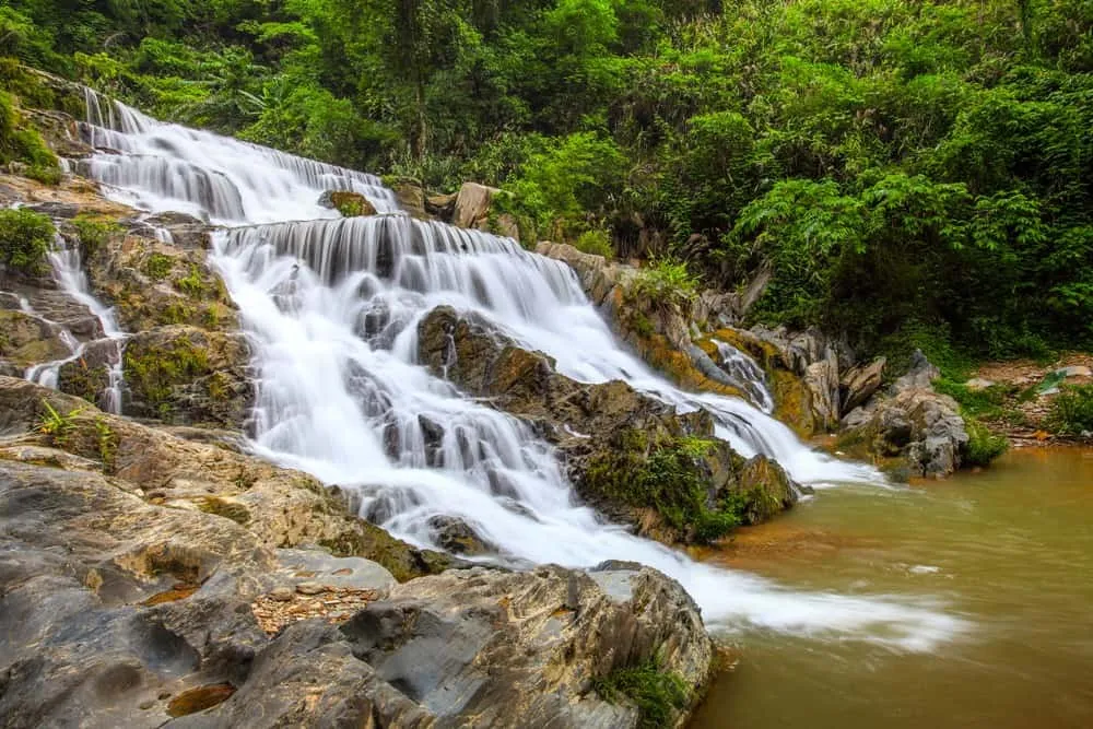
Klong Tron Waterfall, also known as Huai Pong Waterfall, is the easiest of the falls to visit, close to the park road. Its lower section has four tiers dropping about 20 metres; a second, taller 30-metre drop lies roughly 1.5 km further along the creek, reached by walking upstream rather than by trail. Huai Kom Waterfall, a set of three linked falls near Ban Huai Kom, needs a five-kilometre walk from the village since no road reaches it — the same applies to Pha Phumiang, a high cliff between Ban Ton Kanoon and Ban Bang Kham Pom with sweeping views over the surrounding valley; camping is possible on its summit plateau but there are no facilities.
Chan Cave, on the park’s eastern side, is the one feature you can reach by car. It’s a mid-sized marble cave about 200 metres deep and 15 metres wide, with stalactites, stalagmites and a resident bat colony — bring a torch, since there’s no lighting inside.
Insider Tip: Most of the park’s named waterfalls beyond Klong Tron itself require a guide or at least local directions — trails aren’t consistently marked. Ask at the park office before setting out for Huai Kom or Pha Phumiang.
- Entry fee: 100 THB adult / 50 THB child (foreigners); 20 THB adult / 10 THB child (Thai nationals)
- Hours: Daily 06:00-18:00
- Area: 518.8 sq km
- Renamed: Klong Tron (2003) to Ton Sak Yai (2012)
- Easiest waterfall to reach: Klong Tron/Huai Pong, near the park road
Watch out: Several of the park’s headline features — Huai Kom Waterfall, Pha Phumiang cliff — have no road access and involve several kilometres on foot each way. Confirm current trail conditions at the park office rather than assuming a route is walkable after heavy rain.
The park sits in Uttaradit province, reached via Nam Pat district roads off Highway 1047; there’s no public transport to the park entrance, so a private car or hired driver is the practical option. Combine a visit with the giant teak tree stop for a fuller day out, since the two are administratively one park but physically separate points of interest.
Location & Directions
Nam Pat, Uttaradit
Uttaradit, Thailand
Show your taxi or Grab driver
อุทยานแห่งชาติต้นสักใหญ่
Frequently Asked Questions
How much does it cost to enter Ton Sak Yai National Park?
Is this the same place as the giant teak tree?
Which waterfalls can I reach without a long hike?
What's inside Chan Cave?
When was the park renamed from Klong Tron to Ton Sak Yai?
Spotted something out of date or incorrect? Let us know
Stay Near Ton Sak Yai National Park
Live prices for places closest to Ton Sak Yai National Park — tap a pin to compare.